Get every episode summarized
Each time Weather With Enthusiasm ! publishes, we email you a written briefing from the transcript — the topics, who appeared, and any specific claims, with the ad reads skipped.
Email me new episodesFree for 3 shows. No card needed.
About this episode
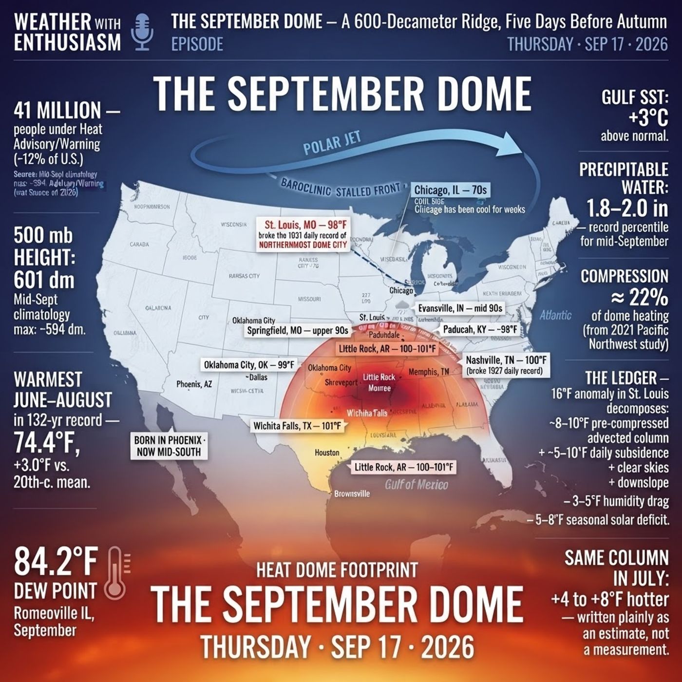
1. Introduction — An Extraordinary Heat Dome
2. Why This Heat Dome Deserves Attention
3. The Ring of Fire and Normal vs. Abnormal September Weather
4. Record Heat and Dew Points in St. Louis
5. Comparing 1931 to Today: Drought Year Temperatures
6. July vs. September: The Solar Insolation Difference
7. Lessons from Spain: Latitude and Seasonal Temperature Gaps
8. What This Heat Would Feel Like in July
9. Factoring in Drought and Cornfield Temperatures
10. St. Louis Heat Records and Historical Context
11. Understanding Decameters and Heat Dome Strength
12. Compressional Warming Explained
13. Breaking Down the Numbers: How Hot Is It Really?
14. Why This Heat Dome Won't Quit: The Missing Hurricanes
15. What It Will Take to End the Heat Dome
16. The Equinox, Autumn Storms, and the Coming Change
17. Looking Ahead to Yom Kippur and the End of the Heat
18. Behind the Scenes: Making the Podcast with AI
19. Closing Thoughts and Thank You
HASHTAGS
#WeatherWithEnthusiasm #HeatDome #WeatherPodcast #ExtremeHeat #SeptemberHeat #ClimateWatch #WeatherNerd #StLouisWeather #HeatWave #DewPoint #CompressionalWarming #RingOfFire #WeatherForecast #AutumnEquinox #DroughtYear #WeatherEnthusiast #ClimateData #SynopticWeather #WeatherScience #EndOfSummer
Become a supporter of this podcast: https://www.spreaker.com/podcast/weather-with-enthusiasm--4911017/support.
Not affiliated with any government agency or academic institution. Presented for educational and entertainment purposes — with meaning.
Support the show — exclusive bonus episodes available to subscribers for just $2/month at spreaker.com/organization/kol-simcha
Get every episode summarized
Each time Weather With Enthusiasm ! publishes, we email you a written briefing from the transcript — the topics, who appeared, and any specific claims, with the ad reads skipped.
Email me new episodesFree for 3 shows. No card needed.
Hosts & guests
Transcript ready
222 searchable segments. Every word is indexed and playable.
Full transcript
Weather With Enthusiasm ! — Extraordinary Heat: Developing an appreciation. Machine-transcribed; use the interactive transcript above to jump the player to any line.
With the football season underway, it's time to see how your predictions are shaping up CalShi America's number one prediction market platform let you trade those predictions in a live market Delay is trading at 53% to beat Denver meaning a hundred dollar trade pays out 183 with a win download CalShi use code heart to get $25 when you trade 25 18 plus only restrictions and eligibility apply trading involves risk not available in all jurisdictions prices values and markets make different from those mentioned for more C CalShi.com slash regulatory CalShi trade on anything Good evening. It's Thursday evening September 17th. You're listening to weather with enthusiasm We have something totally extraordinary that's going on the weather map this evening and For someone who has a weather podcast to not speak about this and Cannot point it out. I think would be a tremendous ovel to the podcast and the flaw those of us that haven't understanding of The synaptic weather set up in what produces temperatures and
How things come about have got to appreciate the fact that We have an extraordinary heat dome now We've heard those words a lot we hear it all the time and therefore we become numb I think many of us become numb and don't really think it's so extraordinary anymore And many of us might not even find the temperatures to be so extraordinary So I wanted to try this evening to translate what's going on right now To make it understandable to just regular folks so that people could start to appreciate The extreme the totally extreme situation that we have and we don't get situations like this very often It's a true rarity and in the past usually when it happens it happens in such a way that People are aware of it people do appreciate it People haven't understanding of what's going on because it translates to extraordinary surface temperatures
But today over the past couple of weeks That Might have gone missed by many people first of all We have much of the country right now is not experiencing it And those places which are not experiencing this are actually experiencing Normal September weather those people who are under the heat dome Could probably barely believe it and that's something that also is totally phenomenal We have a ring of fire and usually with the ring of fire we have You know we have cooler air to the north and just sizzling hot air within the heat dome But cooler air usually means dryer air these types of things happen in July Well, we have right now we're headed we're well into September We're in the middle of September we even into the second half of September and September is going On as usual when you go up to the north we've already had our first snowstorm in the mountain areas in this country
Yet the heat is just as intense for real. It's just as intense as it was in July There's really no difference at all the duke points are also Totally phenomenal duke points in the 70s the temperature in St. Louis today the high was 99 with a duke point in the low 70s That's a record the previous record was 97 degrees set back in 1931 I think 1931 is a great year to demonstrate the difference of the impact that solar activity The solar insulation hasn't st. Louis when you compare July to September If you just compare the maximum temperatures because It was a year of drought. It was a dust bowl year and Year were things were similar and July as they weren't September the maximum temperature in July that year was 104 degrees and in September the maximum temperature was 97 degrees so It's about a seven degree difference now if you go to some of the cities like out in Spain
Which have a similar latitude to what st. Louis has and tends to be under the same air mass more or less the months of July August and September You'll see that there actually is a 10 to 11 degree difference between July and September Those are some of the drier cities. I think in st. Louis it's safe to say that it's about a three or four degree Inselceous we would be dealing with temperatures about three or four degrees warmer Celsius in July Then they are right now had all of this been taking place in July Four degrees Celsius is about a seven point two degrees Fahrenheit It wouldn't surprise me if it's really eight degrees Fahrenheit It happens to be that the average high in st. Louis in July is 90 degrees and average high in September is 81 degrees That's a nine degree difference that doesn't really tell you the whole story though Because we tend to be south of the jet stream in July We tend to go back and forth in the month of September But it still could tell you more or less the story so
99 degrees is very hot But you know if you've been hearing 99 degrees all summer you kind of lose the sensitivity to it But when you say 99 would equal 106 or 107 106 is Aureroutine st. Louis so if you were to go back to July It's very defensible to say that you know the the days are two hours longer Which means the nights are two hours shorter and the sun angle is 20 degrees higher up in the sky 20 degrees higher up in the sky a 72 degrees sun angle when you in the beginning of July versus a 52 degrees sun angle right now So it's 20 degrees higher up in the sky when you factor all of that together To say that the temperature would be seven degrees warmer is not such a Far-fetched thing and it might even be hotter than that because we have cities where it's 11 degrees warmer So we have cities which are in the same degree latitude which remain in the same air mass
there are cities in Spain that Would demonstrate a 10 to 11 degree difference between July and September just face upon solar Insolation there's no way to give an exact number But that's what we would be looking at approximately So summer between I guess 7 to 11 degrees we're putting it at 106 You know it was 99 today So you put that up 7 degrees 106 it could be hotter But now let's pretend it wasn't humid let's pretend we were dealing with a year of drought something like year of 2012 It's very defensible you can never prove any of this There it's very defensible to say that the temperatures with these six degrees hotter in a year of drought at least Maybe even hotter than that we have four casters to tell us that in the cornfields Temperatures tend to be six degrees cooler and a lot of that is due to the humidity The heat index ends up being higher in the cornfields or ends up being equivalent
But temperatures are about six degrees cooler. So You have two points in the 70s that's not just a little bit humid. That's very humid air Especially this time of the year so if you were to Bring that down to two points in the 50s It's very reasonable to say that the temperatures would be even six degrees hotter So that puts us up at 112 degrees for the month of July if it was 112 in St. Louis Does that not leave an impression on anyone in 12 in St. Louis the hottest temperature ever in St. Louis was 115 degrees That was in 1954 There's no way to say that it wouldn't have been that hot but 112 I think is Super reasonable to take this air mass and put it into July You know we have decimators national weather services all over the place keep having the number 600 600 decimators It's a very high number We also are able to figure out based the phoenix is very good at this phoenix is an excellent city to figure out
How much additional Compressional they these heat domes produce heat from compressional warming That's what's called the the sinking air the sinking air produces heat It's like putting air into a bicycle pump the there's compression that itself makes it hot They say some of the pumps get hot the tire might get hot So even without the sun the air itself just gets hot because of the how much pressure the rapidly sinking air that makes it hot So we don't know how much air is sinking exactly But what we do know is the geographical heights at the number of feet you have to go up before the barometric pressure is 500 mb that tends to be much higher in a heat dome and this stronger the heat dome the higher it is Many people have said that 588 is the cutoff for a heat dome Some have said there really isn't a real cutoff but 588 decimators could be considered a cutoff and
In 1995 heat wave which was a deadly heat wave some say the most deadly heat wave in the Midwest Had a 594 decimator this morning Dallas, Texas was coming in a 593 decimators We've seen even today. We had national weather services down in the south Having us at 600 and one this heat dome it's 601 decimators In a certain way, it's actually become stronger It's some states at its peak today. We had national weather service forecast offices quoting the exact same numbers of 601 decimators It's really It might even be the highest we've seen all summer for many of these cities And it's right now September 17th. So who would ever thought of such a thing? So how much of this heat is due to the compressional warming? so Based upon things that have been said from the Phoenix national weather service We have reason to believe that for every decimator you go up We're talking about a half a degree to one degree Fahrenheit
So you know you take a good old Let's say in recent years you have around say 592 decimator heat wave in St. Louis with temperatures in the mid 90s You know you push that up to 600 So we're talking about maybe four degrees Anywhere from four to eight degrees. Let's just say four degrees is due to the compressional warming So the This powerhouse heat dome is responsible for at least probably four degrees of that 99 degrees. You have Meaning if it wasn't such a phenomenal heat dome Let's say the high would have only been 95 degrees maybe we don't really have numbers for all of this another thing The national weather service spoke about We're winds blowing off the Ozark plateau that also these down slope winds Increases additional compressional warming how much I don't know let's say one degree Celsius Let's say one or two degrees Celsius. So we say two or three degrees. Let's say two degrees Fahrenheit
So you'll notice a lot of times St. Louis is a couple degrees warmer than other places and that's at the airport not just downtown So Let's say if it wasn't for that and if it wasn't for the intense heat dome the high would be 93 in St. Louis Okay, you put that into July Okay, so with you know July would be 99 everything sounds normal then and in a drought 105 Okay, we've 104 103 and 104 seems more normal for years of doubt 102 is really almost an annual occurrence in St. Louis for peak heating Generally in the 90s and then in the summer of 2012 we had a high of 108 that summer But that was also a year of drought. So you see that six degrees That's a pretty reasonable estimate. So to say it in 12 You know, that's what this is Because it's September we're only hearing highs of 99 and Most of the country may not even know what's going on
But this heat dome has been here for weeks for weeks. It started off in the deserts, Southwest In the month of August The question is what's gonna break it? How is it gonna come to an end? Why has it not come to an end? So Those of us that study the weather and read everything That possibly is made on weather are probably familiar with How heatoms come to an end? So first of all they'll say well the heat dome can't come to an end It's just there and it never ends What in the world something has to happen in order for to break So what happens is the hurricanes that's what breaks it the problem is this year We don't have any Atlantic hurricanes. There are no hurricanes in the Atlantic Ocean So we have a problem the heat dome is not ending. It just goes on and on So Now that we don't have hurricanes the heat dome is not ending So what is gonna bring it to an end is the heat dome gonna just continue until we get to winter So here's the people first of all people don't know until after it happens, but basically a lot of times
You know the heat dome is what directs things But sometimes the things is what directs the heat dome So does the heat dome is it gonna direct the storm system or with the storm system direct the heat dome? That what determines that is based upon what is more powerful? So a hurricane a powerhouse hurricane is stronger than a heat dome But a tropical storm. I think the heat dome is stronger than a tropical storm What we need right now is a powerful autumn storm and those things start to develop really after the equinox or right around the equinox Because that's when we start to get Parts of our globe go into 24 hours of night So the temperatures really start to take a dive Up north and contrast in temperatures that enhance the jet stream and that's what gets these storm systems going So once we get these strong storm systems going the heat dome should be able to come to an end even without a hurricane right now it looks like
That's expected to happen on monday on yom kipper We're gonna see the ending of the heat dome and at this point It's gonna be black and white. It's a black and white issue at this point We rarely go through this Where it's gonna end and it's gonna end it's wanted ends this it's not Normal for to come back. It doesn't mean it won't but It's not supposed it's not gonna come back I don't I don't believe anyone's forecasting it to come back. There's if it comes back It's completely against the climate to come back It's it would be as abnormal. I think as just the heat dome developing in the first place in late september right now The heat dome is left over from the summer. It has not gone away the heat dome is left over. This is going on all summer Nothing has been able to break it nothing. It's moved around but nothing has broken It looks like the beginning of next week We have a storm system that's strong enough to finally break it to push the thing out and once it's broken
It's likely not going to develop again until next summer So that's what the thinking is the people who have been living in this sweltering heat are probably gonna be shocked To know there's gonna be September air. We're dealing with autumn We have cool air as we mentioned be already had our first snowstorm up in the intermountain area now there are some podcasts that I made that I worked very hard on their AI I used AI voice and People don't understand what AI is by the way So it's say it was made by AI that doesn't mean that You just Said make a podcast and then the person put it on it doesn't mean that to make a quality pot You have to word it right you have to know what you want and you have to have it fact checked You have to listen to it and some of these podcasts are totally phenomenal the ones done by AI and Sometimes it and that people could enjoy it and especially
Those that are into the weather and even those that are not into the weather Maybe could develop an appreciation for what's going on in our country right now and The people who are living with this heat have been living with it all summer and if anything it got even hotter in the month of September and You should just know that the things that are put on with AI on the podcast weather with enthusiasm It's rare for there to be an inaccuracy and it's usually fixed right away. All right, so thank you for listening With the football season underway It's time to see how your predictions are shaping up CalShi America's number one prediction market platform Let you trade those predictions in a live market LA is trading at 53% to beat Denver Meaning a hundred dollar trade pays out 183 with a win download CalShi use code heart to get $25 when you trade 25 18 plus only restrictions and eligibility apply trading involves risk not available in all jurisdictions prices values and markets make
Different from those mentioned for more see CalShi.com slash regulatory CalShi trade on anything
More episodes
More from Weather With Enthusiasm !

The Window (D-Day, 1944)- Weather
Weather With Enthusiasm !

When Heaven and Earth Were Conscripted — The Exodus | A History Special
Weather With Enthusiasm !

National Weather Report — Monday, September 14, 2026: Record Late-Season Heat, F...
Weather With Enthusiasm !

Weather_With_Enthusiasm_September_11_2026
Weather With Enthusiasm !