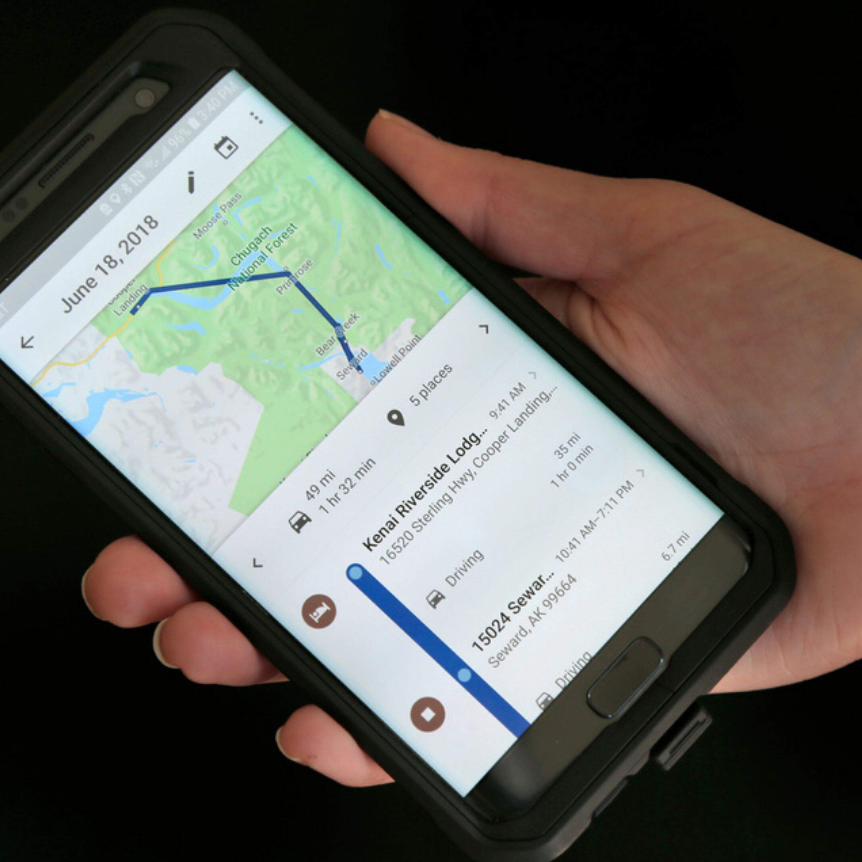
What we have lost now that we found the blue dot
About this episode
On Point with Meghna Chakrabarti is made possible by:
Since Google Maps launched in 2005, the little blue dot has come to symbolize a transformation in how we navigate through the world -- wholly reliant on GPS. But what do we lose when we no longer get lost?
*** Thank you for listening. Help power On Point by making a donation here: wbur.org/giveonpoint
Get every episode summarized
Each time On Point with Meghna Chakrabarti publishes, we email you a written briefing from the transcript — the topics, who appeared, and any specific claims, with the ad reads skipped.
Email me new episodesFree for 3 shows. No card needed.
Hosts & guests

Transcript ready
303 searchable segments. Every word is indexed and playable.
Full transcript
On Point with Meghna Chakrabarti — What we have lost now that we found the blue dot. Machine-transcribed; use the interactive transcript above to jump the player to any line.
Support for WBUR comes from MathWorks, creator of MATLAB and Simulink Software, to design and develop engineered systems, accelerating the pace of discovery in engineering and science. Learn more at MathWorks.com. Hey, it's Willis, a producer here at OnPoint. One of my favorite parts about being a producer here is hearing from you, our listeners about the show. What you like, what you thought of our guests, what you thought of what they had to say, and what topics you hope will cover. And what I love about the new OnPoint Club is that we're going to have more opportunities to share what's behind the scenes and how we put the show together for you. If you're not a member of the OnPoint Club yet, click on the link in the episode description to sign up. For $7 a month, you'll get first access to the Jackpot each week, other exclusive content, and you'll be the first to know about special live events. Now stick around for today's show.
WBUR Podcast. Boston. Sheila Persell has a lot of treasured memories from her childhood, including all the times her family piled into the car and hit the road. No maps. We didn't use anything that I can remember. I don't remember seeing an Atlas till I was in college, so we definitely didn't have any GPS. So my parents just seemed to know where they were going. Most of the time. There were a few wrong turns here and there. I think everyone, so while my mom would start to get nervous in a car with five small children, as she start to see that maybe we were getting a little too far from civilization or too far from where she thought we were supposed to be heading and she'd start to ask, you know, do we want to stop and ask for directions? Maybe we want to ask and see if this is the way we're supposed to be heading. Sometimes we would, but more often than not, my dad would find that as an opportunity to turn it into, you know, some great story, something that would pull us all in.
Sheila grew up in Guayakil, Ecuador. Her family spent a lot of time in the car, often driving to and from the beach. She was born in 1978. So no fancy gadgets in the car, no screens, just her parents' imaginations. They would tell these great terrifying stories. If it was daytime, it might be fairies and mermaids, but if it's nighttime, it was always a horror story. The scarier the better if my mom had her way. But it would just turn whatever, you know, whatever detour, whatever lost adventure we were on. Into something that became memorable, that became something that we would keep talking about and laughing about year after year. You know, how it was more scared than who really thought the car had broken down or, you know, that time we got lost and ended up stopping and asking for directions and getting lunch and it turned out to be an ostrich farm. And so, you know, and the ostrich took that's had and we're eating, you know, ostrich burgers.
These accidental detours became a beloved part of her family's car trips as much a part of the journey as the destinations themselves. They even gave those detours a name. The Jacobson shortcut coined after Sheila's father. And we love it and we celebrate it and it just means we got lost and took the long way home and and you know, you know, it means that we were lost. But it also means that you missed out on something. If you weren't on it, you missed out. Everybody be like, oh, would you get lost and go, oh, Jacobson shortcut. And then you tell them and we met this person or and we had this delicious thing or and the ostrich stole my hat and it ends up being more fun than if we had just gotten from A to B. This is on point. I'm Megna Chacroverti. Sheila Perseaux lives in Timnath, Colorado now and those Jacobson shortcuts seem even more precious these days because it's next to impossible to get lost anymore.
Whether it's in your car or on your phone, GPS systems have given us the power to know exactly where we are and how to get where we want to go almost anywhere on planet earth. The technology is also a critical part of much more than simple mapping systems. GPS in fact has changed how all of us live and for the better. But have we lost a little something to I mean, have we lost the opportunity to just get lost to look up from our phones, not know where we are and discover something delightful and new. Well, that is one of the questions that Catherine Dunne asks in her new book, Little Blue Dot, how GPS shaped the modern world and she joins us now, Catherine, welcome to on point. Thanks so much for having me, Megna. Okay, so before we get into the technical specifics of GPS, I just have to ask you, are you a frequent Google Maps or GPS user yourself?
Yeah, I'm constant people keep asking me if writing this book has changed my relationship with Google Maps and unfortunately the answer is not at all. I once managed to get lost in about a three block radius for 45 minutes and stood my own husband up at the restaurant and he could not believe how is this possible and I said my phone died. I was completely defenseless. So yeah, Guilty is charged. Well, actually, you're in London right now and I have to say that a three block radius in London given how old the city is and how winding and small and maze like some of those streets can be. I very much sympathize that you could get lost there is that where it happened. Yeah, it was around Carnaby Street. So if it had been a nice grid, a nice orderly grid system, I would be okay, but this was a real accomplishment. Let's just put it that way. I had to stop some finished tourists and get them to the restaurant. And they were like, why why are you in this position? I was like, I am but a lemmings. What can I say?
No, London is truly an ancient maze and it makes it delightful. It is not New York City. Let's just put it that way. Okay, but you're not alone, obviously, like just about everyone in some way, shape or form, if they especially if they have a smartphone are using GPS, even if you're not using maps, we are all using GPS system sort of in our in broader society and how infrastructure is created these days. But let's go back though and talk about how this system of global positioning became public and so ubiquitous. I mean, where would you start that story? Let's take it back to the Vietnam War, the end of the Vietnam War. There's this whole half story, half myth around it this this weekend called the Lonely Halls meeting and it's sort of when all of these officials gathered in the Pentagon and they set out what became the global positioning system. And why it's so important that it was 1973 is because this is a precision bombing system. It was built to drop bombs from planes and it was built because you know the Vietnam War, the US Air Force didn't really have the precision that they wanted to bomb, you know, the Ho Chi Minh Trail going from north to South Vietnam.
So that's that's the moment a lot of people point to but yeah, you can go back to World War two and you can go back even further if you want to look at kind of how we navigate and how we understand the world around us. World War two, I wasn't familiar with that because I was just assumed that it was this is a product of the era of satellites. It is satellites, but it's also radio waves and navigating using radio waves is kind of a 1930's era thing, you know, the collision of commercial radios and the collision of commercial aviation. They started using landing beams to help pilots land at Berlin Airport and London Airport and across the US, you know, leading up to World War two. And once you get into World War two, the British and the Germans start kind of engaging this battle and the Americans as time goes on to use radio beams that they can sort of hear with their ears to drop bombs in the dark.
So that's the predecessor to the system we have now, obviously now we rely the space age sort of changed everything, but this is all about radio beams and it's all about the electromagnetic world. That's what we're relying on. So you're talking about man-made systems in general, right? Like just when we moved beyond the using the lost art, I have to say, of using stars or the sun or even just simple time keeping, right, to know where we are. Okay, that's really interesting. Now there's another, let's move back into the Vietnam and post Vietnam era. I think there's another event that caused the or advanced sadly GPS and that was the crash of a Korean Airlines plane. Yeah, yeah, that was kind of a summonal moment in GPS history in 1983. It was this crash that occurred at an incredibly, incredibly, incredibly tense time and during the Cold War. And basically it was a Korean Airlines jet. It was going from JFK to Seoul and at the time they would stop over in Alaska.
And then they would kind of take south of the Bering Strait. They would have down to Asia. And what happened is there's a navigational error something went wrong and instead of flying kind of south, they blew straight into the Soviet Union. And the USSR fighter pilots shot it down and more than 200, 250 people died. It was this absolutely huge disaster. And in the aftermath of that, Ronald Reagan and his press secretary came out and said, we have this tool kind of in the bowels of the Pentagon. It wasn't finished. It wouldn't be finished for more than another 10 years. But we have this tool and it's going to make sure that this never happens again. This horrible idea that you could just eat completely off track and have no idea. Evening Buyers Remorse
Buyers New Car I'll be moving in. Let's get started. Sorry, I think there's been a mistake. I bought it from Carvana. You what? Yeah, great price. I even have seven days to love it or return it. So there's no... No, no Buyers Remorse. More like Buyers Rejoice. I guess I'll let myself out. Congratulations. I mean it. Buyers Rejoice. Buy your car today on Carvana. Limitations and exclusions may apply. See your seven day return policy at Carvana.com. There is something powerful about the sound of the human voice. Beautifully produced audio has the unique power to connect and inspire. Tell your organization's story with a custom podcast from City Space Productions, a creative studio from WBUR's Business Partnership Team. Become a thought leader. We're a crew new talent. Reach new audiences. Whatever your goal, we can help. Discover how the magic is made at WBUR.org slash creative studio.
You want to talk about poetry? Yeah, we do, Henry Winkler. I'm journalist Faith Saley. I'm Poet Maggie Smith. And we are the co-hosts of You Could Make This Beautiful, where we talk to actors. Oh my God. Poetry emergency. Comedians. We met on poetrydates.com. And teachers about poetry in all its forms. It's just one of those poems where you're like, if I read this to someone on a date, it's on. We're going to get the check. You could make this beautiful wherever you get your podcasts. Catherine, we actually put the call out to on-point listeners to get their opinions of GPS systems and if and how they use them. And we got a lot of responses. Let's just start with two of them now. This is George Scarbeck in Albuquerque, New Mexico. And George says he does not use GPS when he travels.
He's still in fact studies a paper map on the airplane before he gets to his destination. And he makes sure to memorize the important places that he needs to know like public transit stops and where he's staying. Once I arrive, that map goes into my back pocket and comes out only in emergencies or for lapses in memory. This allows me to blend in a little bit better as a local, as opposed to standing out as a lost tourist. I have freezed up my eyes to view the sites that have come so far to enjoy and leaves me relying only on my memory rather than on Wi-Fi or cell service. Good on you George. On the other hand, we have Jeremy Grobesmith. He says he used to be like George and pride himself on not using GPS, but then... As I moved to a new city and Google Maps became more and more prevalent, I began using it as I drive for work. I needed to know exactly where I was going, what traffic was there and what may be in the road.
Now I use Google Maps exclusively to navigate my way around Charlotte. I think it's fantastic. I couldn't live without it. You could go find fishing spots. You could find creeks at rivers. You can know where the wrecks are. You get to know where the cops are in traffic. It's a great service and I go everywhere with GPS. A little taste there of how GPS has really changed how at least some on-point listeners live. There's this beautiful line in your book though about how GPS may be one of the greatest gifts that the American people gave to the world. Correct me if I'm wrong, but even though initial use is worth for the military, was it available to the public from the start? It's kind of incredible that the existence of the system was never classified. From very early on it was always dual use as they call it, civilian and military. There had been a bit of a predecessor system and that had also been for civilians. When I see it was open to the public, it was open to a very special kind of person, I would say, through the 80s.
You have to know about it and you have to be able to build a receiver or get an extraordinarily expensive receiver. So the first adopters, surveyors, surveyors absolutely loved it any sort of maritime and then eventually sort of aviation. But yeah, it was a real industrial tool. It was really for these kind of mapping applications. And regular people, if you didn't have that kind of job, you probably wouldn't have encountered it. Right, but even the public access at the time if I understand correctly, the data that you got wasn't as accurate as what the military got. Correct. Yeah, it wasn't like they call it selective availability and basically they put an artificial error on it. They made it a little bit less accurate. So there are two sets of signals, military and civilian. The big difference at this point is that the military signal is encrypted. But yeah, the civilian signal, they basically realized the system was too good. It was too accurate. It's one way because it's built for a war and it was 24 seven all over the world.
So if America had it, then they had it in the Middle East as well, basically. So they put this artificial error on it. And that was, you know, it was a difference of, you know, 20 meters versus 100 meters or whatever. So if you're hiking, if you're sailing, GPS was still really useful. But it wasn't quite what we associated with today, the super accuracy. Okay, so you said something really important there. And that is the way the system was created from the start with the satellites that the United States put up in space. If America had it, the rest of the world had it. So let's talk about actually how it works. And why what you said is true. I mean, how does GPS work? Yeah, people are like, I'm just realizing. I had no idea. No, it's such a good question. One of the people in the book who worked on it in the 80s, he said, the thing is, you really need to understand this is a computer in the space talking to a computer in your phone or wherever talking to a computer in your phone.
Wherever talking to a computer on the ground stations. This is really complex computing and physics that's happening. And it's pretty incredible because this concept was developed and honed in the early 70s before we had personal computers. So we're encircled by this web of satellites, basically. I am sitting here in London. My phone is next to me. There is a chip in my phone. And it is getting signals from four different satellites at all times wherever I am in the world. And that's because it's calculating for four equations, longitude and latitude. So I'm very close to the prime meridian here. So you have a good idea. My altitude, I'm sitting on the sixth floor. That's something that it's calculating. And then the fourth thing is time or it's a clock offset. This is the hardest to understand. And I call it the special sauce of GPS and what makes it almost as important as navigation or more important sometimes. You've got a atomic clocks in the satellite and it's sort of giving us this synchronized time here on Earth.
So the reason why everyone gets this is because let's stick with the phone example. Your phone is receiving this. The satellites are just sending out this information and the non-ingripted data. That's why anyone can get it. Does that right? Yeah. Exactly. It's just raining down on us. People often think that GPS is tracking you. Actually, it's more, you know, in the physics sense, it's more accurate to say that you are tracking the satellites. Yeah. It's it's not GPS. The GPS system has no idea where you are. That's a little pedantic in everyday life because once we get our location or our phone gets our location, we do transmitted out. We turned it into this two way system. But GPS itself was built for war. So that whole idea was you don't want to give away your location. And this is why pretty early on the US government realized they had no idea how many people were using this thing. Right. They knew it was getting insanely popular, but they didn't actually have the numbers. Interesting. Hence the greatest gift. One of the greatest gifts.
Yeah. Exactly. The American people gave. And again, this is so fascinating, but you said something that we should also underscore, which is a lot of people might think that when they use Google Maps, by virtue of getting those GPS signals, they are giving away their location. But as you said, that is not what's giving away where you are. It's when your phone is connecting to via location services through the cellular network essentially or through through Wi-Fi. Your phone is actually telling other networks where you are. Yeah. Exactly. You are giving your location away, but that's not GPS's fault. Okay. You could still get a GPS receiver. You could go out in the woods and you could still use it as a one way system if you have the technology to do that. Amazing. Okay. So let's go back to our listeners because we did get a lot of people who were honest about how much they love GPS. This is Keith Stern. He's a Newton Massachusetts. And he loves GPS so much. He thinks it's creators deserve the Nobel Prize. I still have to think about which way I turn when I go to work, something I've been doing for the past 30 years to the same place from the same start point.
I don't want to venture. I just want to get to my destination desperately. He's honest and I appreciate that. He's got places to be. So here's what's interesting. And I feel like I have experienced this in my own life because I'm old enough to definitely remember when it was just paper maps or triple A's triptics that we used to get. And how the way that through something like Google maps that we are now interacting with our environment, how that's actually maybe turned our navigational ability, it's shrunken it. It's made it more myopic. And so to that point, we actually reached out to some folks who are studying this. And one of them is Mary Hegerty. She leads the spatial thinking lab at the University of California, Santa Barbara. And she has studied how reliance on GPS shapes people's sense of direction. But there's a twist here because Professor Hegerty told us that gathering reliable data for her research from people was actually very, very hard.
We did try in one experiment to say don't use it for a month, but people didn't comply. They're so dependent on it. But Professor Hegerty says that an Israeli researcher actually has been able to observe what people do without GPS. And that's because the Israeli military has been using GPS jamming in the Gaza war and in its operations in Lebanon. And some of that jamming has interfered with GPS signals in parts of Israel as well, forcing many Israelis to occasionally live without GPS. It's really interesting because I mean, some like 20% of people said, you know, I just didn't go to this place. I just stayed home because I was didn't think I could navigate there without my GPS. When they asked people like, well, now that you've had this situation of having to navigate with you at your GPS, do you feel you should work harder on your navigation skills? And they were like, no, we need a better GPS than can be jammed. The other option is of course, to learn how to get around without that little blue dot on your screen. And Professor Hegerty is troubled by the fact that a lot of people don't seem to want this option. They're not interested in maintaining their personal navigational skills.
And she says that most people probably don't realize something important that if you do not use these skills, you lose them. And then people who actually make a point of exploring their environments, rather than, you know, just always taking the same route every time seem to be, you know, better. There's also some interesting research suggesting that the type of environment you grew up in or that you live in makes a difference. So people who grow up in rural environments or cities that are not, you know, kind of more organically developing rather than city block type cities, you know, sometimes have better ability to. And it's like if you're everyday life requires you to do more challenging navigation, then you tend to be better. Hegerty's research has revealed something else that we're losing with an over reliance on the maps on our phones. We're losing our confidence. We ask people like, you know, imagine you're in a strange city, you come out of subway system and you don't quite recognize where you are, you know, how do you feel? You feel really anxious in that situation.
And other people just feel challenged and say, oh, you know, I just look around and like find something that I know or, you know, or whatever. So people who are who say they're more anxious in navigation situations, also depend on GPS. Well, it turns out that some 40 to 50% of an individual's navigational skills are actually genetic. And maybe you're one of those people who really struggles finding your way around, do not feel bad about it. And you're born that way. The other half though of that skill set comes from the environment that you live in. So Professor Hegerty's team wanted to know what environmental factors can actually give a person a better sense of direction. We, you know, ask people about things like, you know, hiking or camping or sailing, you know, basically hobbies that people might have that affect navigation. And really actually predict very much two things predicted. One was people who used to GPS more did worse at our navigation tasks. And people who played video games that involved navigation were better.
And so I think, you know, younger generation is actually getting more navigation experience in video games than they are in the real world. Professor Hegerty recommends that everyone try to maintain their navigational skills without your phone. But she also recommends it for other reasons as well. You know, you might really notice some interesting things along the way. You know, you might learn about some interesting places that might want to visit or meet interesting people when you ask for directions. However, have a more interesting journey. Now Catherine, done. I don't want to sort of over romanticize things and sound like I'm saying, we should go back to the day as we could all read the stars and know exactly where we are. But what do you think about this idea that a lot more people maybe would struggle getting around if they didn't actually have that map on their phones? Yeah, I really do it a lot. Like I said, I'm one of those people who is so bad at directions, it must be genetic. I have to blame my parents for this.
And I had repeatedly when Google Maps wasn't so, so common, tried to correct this in myself and take out paper maps. But one of the things I thought about while writing this book too was that for regular people, you might get lost, you might find something new. I didn't think the stakes were that high after a while, but what really troubled me is the people who might be getting rusty on these skills who really, really, really need them. People who are in charge of a boat, a gas tanker, and the straight of hormones, or people who are flying a plane, or people who are now, I think, in military combat, the US military at one point said like, you have to start preparing not to replace this piece of technology with one with another, but to be able to operate an environment where there just isn't any of it, right? These navigational skills. And this question of, I think what's most troubling is it's getting rusty for all of us, even if your job involves very high stakes navigation.
You want to talk about poetry? Yeah, we do, Henry Winkler. I'm journalist Faith Saley. I'm Poet Maggie Smith. And we are the co-hosts of You Could Make This Beautiful, where we talk to actors. Oh my god. Poetry emergency. Comedians. We met on poetrydates.com. And teachers about poetry in all its forms. It's just one of those poems where you like, if I read this to someone on a day, it's on. We're going to get the check. You know what I mean? You could make this beautiful, wherever you get your podcasts. Let's listen to a couple more on point listeners. This is Margie Rosenbaum of Scarborough Maine. She's 86 years old. And when she drives, she does not use GPS, but she does study Google Maps before the drive. And then she writes down the directions.
And for me, it's important to visualize the destination on that map in relation to nearby locations, whether they're familiar or not. And I come to that conclusion when I ride with one of my grandchildren's driving, they have no idea where they are in relation to the real world. They don't know how long it's going to take them to get there unless GPS tells them it's shocking. Well, here's another take. This is Barb Spencer, who's a truck driver from Bondarant, Iowa. And here's her view on what it means as a truck driver to get lost. As a truck driver, one could always say it's an adventure if you get lost. One you hope doesn't end up with a bridge that doesn't support your weight or maybe an overpass. That's too low for you to get under. Very real, Barb. Thank you so much for those real life views here.
Now, Catherine, we have been focusing a lot, obviously, on the mapping features of GPS because of the fact that now these days it's in virtually every new car. I understand that around the year 2000, the US government really removed all civilian restrictions from GPS. And also the technology regarding the chips needed was cheap enough and small enough to fit inside cars. And then the big one was a little later, right? What? 2008, when Apple announced that the iPhone would have a GPS capability in it, that was kind of really the big turning point, Catherine, right? Yeah, I mean, definitely for me, you might have had a little Tom Tom or something in your car. A lot of people had that, but I think the moment it really exploded was, okay, there is not just Google Maps on the iPhone because that happened in 2007, but there's Google Maps and there's a GPS chip. And now you can find yourself using your brand new expensive 2008 iPhone.
I think that was the moment it really exploded and it became commonplace. It's funny Tom Tom. I haven't heard that brand name in a long time. Yeah, cast your mind back to this antiquity as we talk about my mother. My parents used to have a really old garment. My mom used to hate it. She would say that Garmin would send them to Mars before it got them 30 miles down the road where they needed to go. Okay, but let's actually talk for a moment about how much more than just mapping GPS has penetrated basically modern life. What are some of the other systems, industries, places where GPS has become central for how we operate? Yeah, yeah, it's crazy. When you start looking, I often say that the way you interact with GPS, like the tip of the ice, that's just the tip of the iceberg really. And one of the really important things I talked about time earlier is, is this synchronized time, the fact that it's giving, you know, it's turning a bad clock into a good clock and it's giving this great synchronized beat, you know, boom, boom, boom, time is all together.
And our digital systems are so incredibly dependent on this at this point. So our, you know, our mobile base stations, our electricity grids, anything digital basically relies on incredibly, incredibly precise time, often down to the billions of a second or the nanosecond to agree that, you know, emails or surges of electricity, all these things are getting where they need to be at the time that everybody agrees. Navigation to, you know, you were me using navigation navigation, getting work is one thing, but if you think about the global supply chain as well, you can start with precision planting using your John deer tractor using GPS to precision plant in the Midwest, and you can follow, say corn syrup or wheat, you could follow it every single step of the way and there will be GPS every single part of that process. There's GPS in the shipping containers. There's GPS in the cranes at the port. There's GPS following the ships around the world. So when you start looking at our digital world, you're going to find it absolutely everywhere.
And I think by the time we started interacting with it, just as regular people, it was the infrastructure to synchronize all of that was, was already there, right? Just for us to get it in our iPhones and start using it to get to work, it had to be in the base stations. It had to be in the supply chain. It had to be in the energy grid. It's, it's really crazy how pervasive it is and how little we, we see it once it's there. Another example that you write about is, for example, like the stock market, because time is so wildly important for all kinds of trading that we couldn't have the modern day stock market without this, you know, atomic accuracy as you're saying in timing. And even disaster management, I'm thinking about the horrible catastrophic flooding that happened in Nepal and how almost instantaneously we were getting information about like, where did that start in the Himalaya Mountains? Well, we knew that because of systems that were able to detect not just the shaking of the ground when the flood started, but also when and where. And that was all because of GPS. It's truly remarkable.
So I mean, Catherine, because of the fact that as you're describing GPS is so thoroughly embedded in really basic systems that hold a civilization together these days, that also makes it a potential point of real vulnerability for those same societies. So to learn a little bit more about that, we talked with Todd Humphries, who's a professor of aerospace engineering at the University of Texas at Austin. Now, back in 2007, he was just finishing up his PhD at Cornell University when he came across an article about the potential vulnerabilities of GPS. And keep in mind, at that point in 2007, GPS had only been commercially available for a few years. In this short article, the author Logan Scott was warning the world about the potential of GPS signals being falsified mimicked by so-called spoofers. And it was a hypothetical threat, but he was warning that because the signals coming down from GPS satellites are well understood, aren't encrypted, aren't authenticated, then they could be quite easily fabricated by a device that would be.
So Humphries decided he would try to build a spoofer to test how vulnerable GPS really is. And after about only a year, he thought he figured it out. When it was finally wired together, it was a quiet night around midnight, I think my family was asleep and I fired it up for the first time and tried to spoof my iPhone. I turned on the spoofer, fully expecting that this wasn't going to work because Murphy's Line Engineering stuff never really works on the first try. Yeah, lo and behold, there was the blue dot and it quivered. It shook a little bit and I thought, aha, I've got something. I've affected the internal receiver in this iPhone. And then I typed in a new command on the computer that was controlling the radio and said, make the blue dot go north, like at the desk tree and walking. And that's what happened. Well, this was in 2008 just three years after the launch of Google maps.
And it was the very first publicly acknowledged GPS spoofer and it worked distressingly well. Two decades later, when we talked to Professor Humphries, he still remembers exactly what was going through his head at that moment. So when I saw this blue dot quiver, it was against the backdrop of knowing full well that our society, the world at large, had become quite addicted to this drug of GPS. And now that the drug was manipulable was shown to be something that could betray you, that really shook me because then I could imagine aircraft veering off course ships going astray and all of the confidence that people had build up in this system. Turning against them because they were perhaps not aware that it wasn't so hard to fake the system to fool it into deceiving its users. Now at that time, it was revolutionary that an individual researcher could build a GPS spoofer so easily and so Professor Humphries caught the FBI's attention.
There was a period of four years, I think, where the FBI came to my office once a year to check on whether we were being good stewards of the code that we had written, not allowing it to get out on the internet, making sure that we were following good security protocols in my laboratory so that this spoofing code didn't just somehow leak out and become, you know, common across the globe. Professor Humphries code never leaked, but in 2015, a similar version from Japan did and it was open and available for anyone to download and use. Today, Professor Humphries says basically anyone can make a GPS spoofer after watching a few YouTube videos. Fast forward to 2026 and spoofing has become terribly widespread across Eastern Europe, across the Middle East, straight of Hormuz is just suffused with spoofing GPS spoofing right now on the coast of China and it is a major headache for aircraft.
It has become a problem now where the risk to flying I would say is no longer negligible. Given how dependent entire nations are on GPS, I mean you heard him mention civil aviation, of course there's the military, virtually every form of transportation, even things like the power that flows to your home because time-sinking via GPS is critical to how electricity is distributed through grids. So you'd think the United States would be doing everything in its power to protect such systems, but Professor Humphries believes that if a bad actor wanted to launch a widespread GPS attack on the United States, America would not be ready for it. I'm afraid that people in government administrations, they hear this all the time, you know, it's the Y2K bug, GPS jamming, GPS spoofing, it's our vulnerability to hacking. So it's hard to know what the relative priority of these ticking time bombs is.
And one way, the unfortunate way that we often allow the priorities to be made manifest is to wait for a catastrophe to occur. And then we say, oh, well, that one was important. By the way, he is not alone in his worries about GPS resilience here in the United States. Four-star Admiral Michael Rogers served simultaneously as commander of the U.S. Cyber Command and Director of the National Security Agency between 2014 and 2018, both those posts at the same time. And just earlier this year, in February, he wrote an article in the Hill stating, unequivocally, that quote, a coordinated attack on GPS would ripple across aviation, finance, emergency response, and daily life within minutes, not days. And he issued this warning quote, if GPS goes down, whether because of jamming, spoofing, a cyber attack, or natural disaster, America is dangerously unprepared. A single sustained outage could cost the U.S. economy and estimated $1.6 billion per day.
Okay. So, Catherine, who just got a couple of minutes left here, I mean, your take on this great gift by virtue of it being open, also being so vulnerable. Yeah, it's this really double-edged sword, right? It's elegant, it's useful. We put it in all kinds of things that original architects never expected, but it's incredibly vulnerable. It's incredibly faint, and I think Todd Humphries there would say that the U.S. government has clearly probably known how to spoof and jam and do that for a long time. Maybe the point where they got a little too comfortable was the idea that nobody else would learn how to do it too. And unfortunately, we're in the moment where a lot of people have learned to do it. It's really a feature of modern conflict, directing those drones and counter-attacking is so much part of conflict now, and we can see this spilling out all over the world.
So, yeah, there's been a push for quite a while for the U.S. government to even monitor how much this is happening in the continental United States. I don't think it's really gotten anywhere, but now for governments in Europe, I can see that they're starting to take it really, really seriously, and they have to take it seriously because the risks are just getting too large of something disastrous happening. Well, Katherine, you just gave me an idea for a future on point show. No, I have to say after reading your book and talking with you, I'm never going to look at that little blue dot the same way. Oh, wonderful. She's the author of Little Blue Dot How GPS shaped the modern world. It's been such a pleasure, Katherine. Thank you so much. Thank you for having me. I've really enjoyed it. I'm Megna Chakrabardi. This is on point. The growing backlash against flock cameras, people are vandalizing the networked AI-powered surveillance systems.
Cities are canceling flock contracts, but is there a better way to resolve the tension between public safety and individual privacy? It's totally recent. I'm talking about how to regulate this technology, but we have some OK, in fact, increasingly high quality evidence that it really does help us solve crimes. That's on the next on point.
More episodes
More from On Point with Meghna Chakrabarti

How 9/11 shaped America
On Point with Meghna Chakrabarti
Did the Treasury just make it easier to launder money?
On Point with Meghna Chakrabarti
Who's to blame when AI goes rogue?
On Point with Meghna Chakrabarti
How should e-bikes be regulated?
On Point with Meghna Chakrabarti